
Île de Tombelaine: The Complete Travel Guide (2026)
Île de Tombelaine Travel Guide: Everything You Need to Know (2026)
Île de Tombelaine is a tiny uninhabited tidal island rising just 32 metres above sea level, located roughly 3 km north of Mont-Saint-Michel in the bay of the same name on the Normandy-Brittany border. Once home to a 12th-century priory and later a fortification used during the Hundred Years’ War, the island is now a classified nature reserve protecting grey seals and thousands of nesting seabirds. Access is strictly controlled, making it one of the most restricted and least-visited coastal sites in all of France.
Top 3 Highlights at a Glance
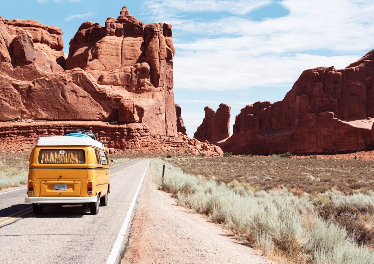
- Guided Bay Crossing on Foot — The only legal way to approach Tombelaine — a 6 km guided walk across tidal sands with quicksand risk.
- Grey Seal Colony — One of France’s only accessible grey seal colonies, with up to 100 individuals visible from the shore.
- Medieval Priory Ruins — 12th-century Benedictine priory remnants perch on the summit, visible but unreachable without special permits.
Scroll down for our complete travel guide with tips on getting there, where to stay, costs and more.
Arrival & Airport
How do I get to Île de Tombelaine?
You reach Île de Tombelaine exclusively on foot across the tidal bay — there is no boat, road, or bridge. In my experience, the only practical base is **Mont-Saint-Michel**, reached by TGV to **Rennes** (**2h15 from Paris Montparnasse**), then a regional bus or taxi covering the final **60 km**. Alternatively, drive the **A84 motorway** and park at the mainland shuttle terminal at **La Caserne**. The island itself requires a licensed guide from associations such as **Découverte de la Baie** — solo crossings are illegal and genuinely dangerous due to shifting quicksand and tides that move at the speed of a galloping horse.
Which airport is closest to Île de Tombelaine?
**Rennes Bretagne Airport (RNS)** is the closest functional airport, approximately **65 km** from Mont-Saint-Michel by road. In my experience it handles limited international routes, so most international travellers fly into **Paris Charles de Gaulle (CDG)**, roughly **370 km** away, and take the TGV to Rennes — a far smoother journey than renting a car in Paris. **Caen Carpiquet Airport (CFR)** is also about **130 km** away and serves UK routes including London. My tip: CDG plus TGV beats any option involving a Paris car rental, especially in summer traffic.
How long does the journey to Île de Tombelaine take from Paris?
Budget a full day of travel from Paris to reach the island’s edge. The **TGV Paris Montparnasse to Rennes** takes **1h25**, then a connecting bus or taxi to Mont-Saint-Michel adds **1h15**. Once at the bay, a guided crossing to the vicinity of Tombelaine takes **2–3 hours** on foot across approximately **6 km** of tidal flats. What surprised me is how many visitors underestimate the tidal schedule — guides depart only at specific windows dictated by low tide, so missing your slot means waiting a full tidal cycle, roughly **12 hours**.
Do I need a car to visit Île de Tombelaine?
No — a car is not necessary but does add flexibility. The **navette shuttle** from the mainland car park at **La Caserne** reaches Mont-Saint-Michel for free and runs continuously. From there, licensed guide services pick up walkers on foot. My tip: if you plan to explore the broader Norman hinterland — **Avranches**, **Cancale**, or the **D-Day beaches** — then renting a car at **Rennes** for around **€45–€70 per day** makes sense. The honest trade-off: parking at La Caserne costs **€14.40 per day** in summer, and summer traffic on the single approach road causes delays of up to **45 minutes**.
City Transport
What are the best areas to stay near Île de Tombelaine?
Stay in **Mont-Saint-Michel village** itself for atmosphere, though rooms are pricier and book out months ahead. **Pontorson**, **7 km** inland, offers cheaper hotels and B&Bs with easy shuttle access. For a quieter experience, the village of **Beauvoir** sits directly at the bay’s edge, **2 km** from the shuttle terminal. In my experience, **Le Mont-Saint-Michel village** is worth at least one night for the magic of the island after the day-trippers leave — after 6 pm the atmosphere transforms completely. Budget travellers do well in Pontorson, where a decent room costs **€60–€90 per night**.
What does accommodation cost near Île de Tombelaine?
Expect to pay **€65–€100 per night** in Pontorson or Beauvoir for a clean double room. Hotels inside Mont-Saint-Michel village — there are fewer than 10 — start at **€150 per night** and spike to **€300+** in July and August. The one camping option, **Camping du Mont-Saint-Michel** in **Beauvoir**, charges around **€25–€35 per pitch** in peak season. My honest warning: hotels inside the Mont-Saint-Michel ramparts are not quiet — medieval walls carry sound, and coach parties arrive before 8 am. For sleeping quality, Pontorson or an inland gîte wins every time.
In high season, how far in advance should I book accommodation near Île de Tombelaine?
Book **at least 3–4 months ahead** for July and August, especially for anything inside Mont-Saint-Michel itself. In my experience, the **Mère Poulard hotel** and its neighbours inside the ramparts sell out by April for summer dates. Guided bay crossing slots with operators like **Chemins de la Baie** also fill weeks in advance — I recommend booking those before your flight. The honest trade-off: even with advance booking, July brings **2.5 million annual visitors** to the Mont-Saint-Michel site, and Tombelaine access groups are capped, so flexibility on your exact date is a real advantage.
Are there special accommodation types worth trying near Île de Tombelaine?
Yes — **chambres d’hôtes** (French B&Bs) in the bay villages are genuinely special here. Farms around **Ardevon** and **Saint-Quentin-sur-le-Homme** offer rooms with direct bay views and home-cooked Norman breakfasts for **€80–€110 per night**. Several **gîtes** sleep 4–6 people and cost **€700–€1,200 per week** — excellent value for families. What surprised me is the quality of farm stays this close to such a major tourist site; they remain well under the radar. My tip: search **Gîtes de France** directly rather than large booking platforms, which list barely a fraction of the local rural options.
Accommodation & Neighbourhoods
What are the must-sees at and around Île de Tombelaine?
The top experience is the **guided tidal crossing** toward Tombelaine itself — standing on the tidal flats with the island rising ahead and Mont-Saint-Michel behind you is extraordinary. Beyond that, **Mont-Saint-Michel Abbey** (**€13 entry**, towers above all else architecturally and historically. The **Scriptorium museum** in the abbey covers medieval manuscript production with genuine artefacts. In the bay, seals haul out on Tombelaine’s northern shore — bring a **300mm+ telephoto lens** for a real view. My honest caveat: actually setting foot on Tombelaine island requires a scientific research permit — tourists can approach but cannot land.
What can I experience for free around Île de Tombelaine?
The **tidal bay panorama** from the causeway and from Mont-Saint-Michel’s outer ramparts costs nothing and rivals any paid viewpoint in France. Walking the **outer ramparts** of Mont-Saint-Michel is free. Watching the **tidal bore** — when the sea returns across the flats at exceptional speed — is free and genuinely dramatic during high-coefficient tides; check **marees.fr** for tide schedules. The village streets of Mont-Saint-Michel below the abbey walls are open to walkers without charge. My tip: the spectacle of the bay at **sunrise**, when mist sits on the flats and Tombelaine floats above it, costs only an early alarm and is the single best free moment in the area.
Which day trips from Île de Tombelaine are possible?
**Cancale**, France’s oyster capital, is **30 km** west and absolutely worth a half-day — oysters at the port market cost **€6–€8 per dozen**. **Avranches**, **25 km** south, holds the original Mont-Saint-Michel manuscripts in the Scriptorial museum (**€8 entry**). The **D-Day beaches** at Omaha and Utah are **120 km** north and require a car or organised tour from **Bayeux**. **Saint-Malo** is **50 km** west by road, a stunning walled city easily combined in a longer day. My honest trade-off: trying to combine two destinations in one day is tempting but leaves you rushing; the bay itself deserves a full day minimum.
What local specialities should I try near Île de Tombelaine?
The bay’s **pre-salé lamb** — raised on salt-marsh grass — is the defining dish of this stretch of Normandy and appears on menus in Mont-Saint-Michel village from **€28–€38 for a main**. **Moules marinières** from the bay are sweet and briny, far better than supermarket versions. **La Mère Poulard’s fluffy omelette** is famous but costs around **€35** — theatrical but honestly more tourist spectacle than gastronomic revelation. Local **Calvados** and **cidre bouché** from nearby orchards are essential; a bottle of quality local cider costs **€4–€6** from a farm shop. My tip: eat pre-salé lamb once — it is genuinely unlike any other lamb.
Highlights & Must-Sees
What makes Île de Tombelaine unique compared to other French destinations?
Tombelaine is the only fully protected, uninhabited tidal island in metropolitan France with recorded medieval monastic history — and you cannot simply visit it. That inaccessibility is itself the point. In my experience, the island creates a rare dynamic: you can see it, photograph it, walk toward it across the flats, observe its seals and seabirds, but you cannot stand on it without a government research permit. This produces a destination where **the approach is the experience**, not the arrival. No beach resort, no café, no queue — just tidal geography, wildlife, and the eerie company of one of Europe’s great medieval silhouettes across 3 km of sand.
How many days should I plan for Île de Tombelaine and the surrounding area?
Plan **3 full days minimum** to do the area justice. Day 1: arrive, walk the outer ramparts, watch the tide at dusk. Day 2: guided bay crossing toward Tombelaine at low tide — this takes the better part of a day including transfer and briefing. Day 3: Mont-Saint-Michel Abbey interior plus the **Archéoscope** or Scriptorial in Avranches. A 4th day allows a run to **Cancale** or **Saint-Malo**. In my experience, one-day visitors to Mont-Saint-Michel leave having seen the island only from a distance and miss the tidal flats entirely — which is the real story of this place.
When is the best time to visit Île de Tombelaine?
**June, July, August, and September** offer the best conditions based on climate data — longer daylight, stable weather, and the highest chance of completing a bay crossing. My personal preference is **mid-June or September**: the bay crossing is still fully operational, guided tour slots are easier to book, and the crowds are noticeably thinner than July. The **highest tidal coefficients** — when the sea retreats furthest and Tombelaine is most exposed — occur around the spring and autumn equinoxes in **March** and **September**, making September particularly dramatic for tide-watching. Avoid August weekends unless booked many months in advance.
Are there local festivals near Île de Tombelaine worth attending?
The **Fête de la Saint-Michel** on **29 September** is the most atmospheric local event — a religious procession to the abbey, local markets, and the equinoctial high tide all coincide in a single weekend. In my experience it’s one of the most underrated autumn festivals in northern France. **Les Grandes Marées** events — organised around exceptional tidal coefficients exceeding **110** — draw crowds to watch the sea reclaim the flats at speed; these are announced on **baie-mont-saint-michel.fr**. The nearby town of **Avranches** hosts a **medieval market** in July that is genuinely local rather than staged for tourists.
Food & Drink
How does the weather affect activities around Île de Tombelaine?
Bay crossings are **cancelled in fog, heavy rain, or storm conditions** — the guide services make the final call on the morning of departure. In my experience, fog is actually common in June and September mornings in the bay, so a 9 am start is riskier than a noon crossing. Wind matters too: the bay is exposed, and a **Force 4–5 westerly** makes the 3-hour walk genuinely cold even in August. Always bring a **waterproof jacket regardless of the forecast** — Norman weather changes within an hour. The upside: overcast light produces extraordinary photographs of both Tombelaine and Mont-Saint-Michel without harsh shadows.
How crowded does Île de Tombelaine get in peak season?
Mont-Saint-Michel receives roughly **2.5 million visitors per year**, making it France’s second most visited monument after the Eiffel Tower. However, almost none of them reach the tidal flats near Tombelaine — guided crossing groups are capped at **around 15–20 people** per departure. The honest truth: the abbey and village are genuinely overwhelming in July and August between **10 am and 5 pm**. The bay crossings feel remote and peaceful by comparison even in peak season. My tip: if you are here purely for Tombelaine and the bay, the crowds at the village are almost irrelevant — you’ll be walking away from them.
How safe is it to visit Île de Tombelaine?
The area is extremely safe from a crime perspective. The genuine danger here is the **tidal bay itself** — not crime. The bay’s tides are among the largest in Europe, with a range of up to **14 metres**, and the quicksand areas shift seasonally. Every year, people attempting unsupported crossings are rescued by emergency services. My firm advice: never cross without a licensed guide, check **marees.fr** before any beach walk, and keep **15 (emergency)** saved on your phone. Mont-Saint-Michel village is perfectly safe at night, though the single narrow street is shoulder-to-shoulder until around 8 pm in summer.
Is English widely spoken near Île de Tombelaine?
Yes — more so than in most French regional destinations. Given Mont-Saint-Michel’s status as an international tourist magnet, **abbey staff, most hotel receptionists, and many restaurant servers** are comfortable in English. The licensed bay crossing guides I have used offer tours in **English, French, and sometimes German**. My honest caveat: book English-language crossing tours specifically — not all departures include English commentary, and the safety briefing matters. In the inland villages of **Pontorson** and **Beauvoir**, French is the working language and a handful of basic phrases will be genuinely appreciated.
Practical Tips
What is the daily budget for visiting Île de Tombelaine?
Budget **€80–€120 per person per day** for a comfortable trip. Breakdown: accommodation in Pontorson **€35–€50** (split double), guided bay crossing **€12–€18 per person**, abbey entry **€13**, lunch **€15–€22**, dinner **€28–€40** for a proper sit-down meal with pre-salé lamb. A tighter budget of **€60/day** is possible camping at Beauvoir and self-catering. The biggest single unexpected cost I see travellers hit is the **parking fee at La Caserne** (**€14.40/day**) on top of petrol — factor it in if driving. Food and drink inside the Mont-Saint-Michel ramparts runs **30–40% more expensive** than identical items in Pontorson.
How does public transport work when visiting Île de Tombelaine?
Public transport covers the main route well but not the final details. **TGV** to Rennes, then **Keolis bus line 6** connects Rennes to Mont-Saint-Michel **3–4 times daily** for around **€15** — journey time **1h10**. From the mainland shuttle terminal, the **free navette shuttle** runs every **10–15 minutes** to the island causeway. No public bus reaches the tidal flats themselves — you need a guide operator to collect you or you walk from the shuttle drop-off. In my experience, a car matters most if you want to visit **Cancale, Saint-Malo, or Avranches** on the same trip; otherwise, train and bus is perfectly workable.
Which apps do you recommend for visiting Île de Tombelaine?
**Marees.fr** (or the iOS/Android app **Tide Graph Pro**) is non-negotiable — check tidal coefficients and times before every bay excursion. **Géoportail** (French IGN) provides the most accurate topographic maps of the bay, far better than Google Maps for tidal flat navigation. **SNCF Connect** handles all train booking from Paris to Rennes. **Via Michelin** beats Google Maps for rural Norman road routing. **Windy** gives the best wind and weather forecast for exposed coastal conditions. My tip: download **offline maps of the bay in Maps.me** before arriving — mobile signal on the tidal flats drops to zero within **1 km** of the shore.